February 9, 2024
Prioritization to Support the Development of an Environmental Impact Statement and Records of Decision
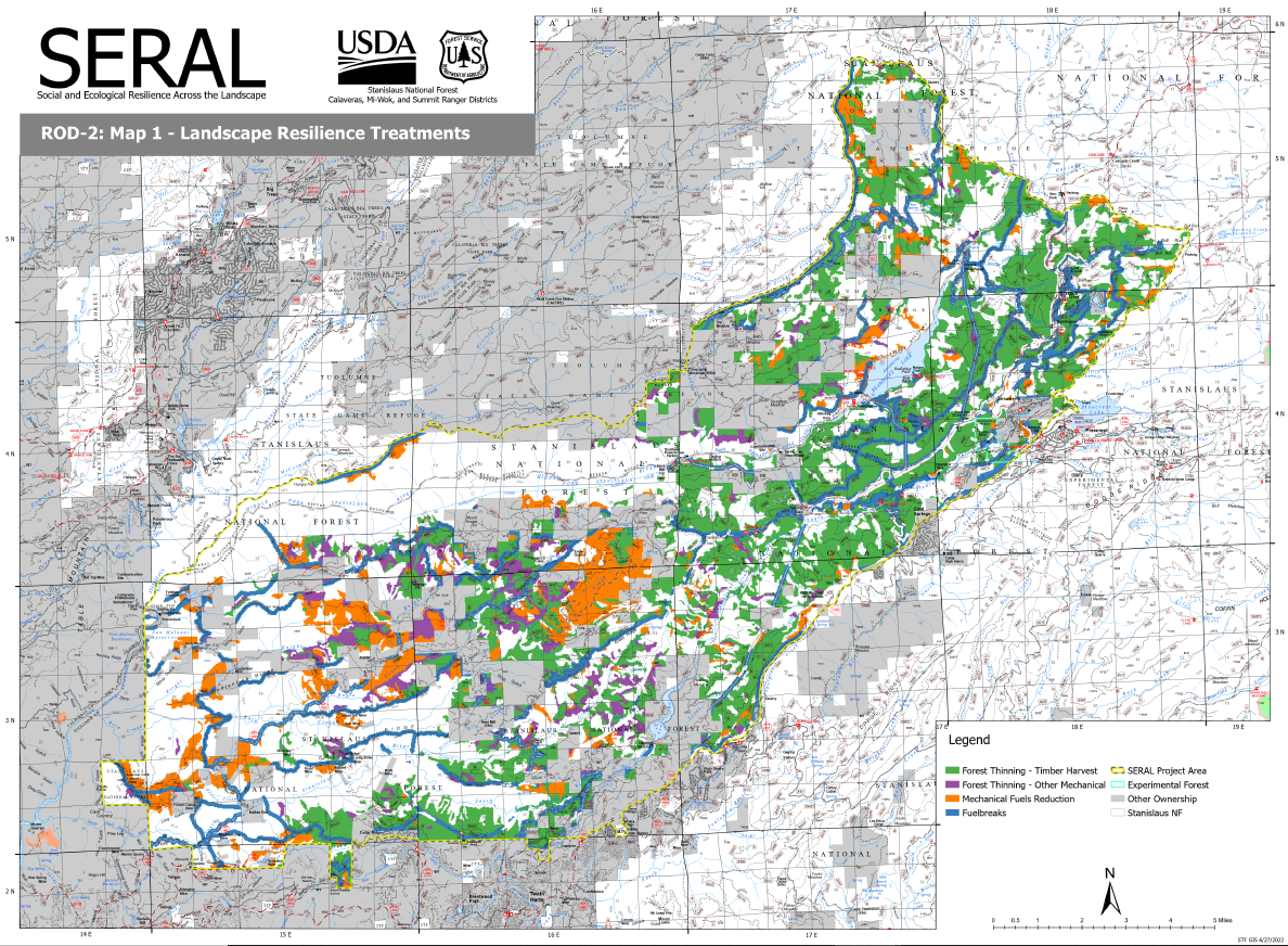
A team from the Pacific Southwest Research Station (PSW) and Region 5 Remote Sensing Lab (F5 RSL) worked with the Stanislaus National Forest resource staff to develop landscape condition spatial data, and with consultation with RMRS scientists, applied the ForSys scenario planning tool to inform landscape restoration needs and select locations proposed for treatment in the Social and Ecological Resilience Across the Landscape (SERAL) project.
The SERAL project area is centrally located on the Stanislaus National Forest in California within the Stanislaus Wildfire Crisis Strategy priority landscape. The project area spans roughly 118,800 acres of multi-jurisdictional or privately owned lands.
SERAL staff on the Stanislaus National Forest used ForSysR to examine scenarios to represent the different action alternatives being proposed and analyzed in the Draft Environmental Impact Statement (DEIS) leveraging ForSys’ ability to examine a large number of scenarios with different objectives, constraints, thresholds, and availability masks.
The scenarios analyzed with ForSys were developed using 1) the SERAL purpose and need statement, 2) the proposed actions, 3) local knowledge, 4) collaborative input, and 5) public comments received during scoping. The SERAL team used ForSys extensively to examine tradeoffs among different modeled scenarios, and leveraged scientifically defensible input data developed by the Forest Service
The final three scenarios prioritized stands with high departure from resilient conditions, and negative expected loss to values from wildfire. The scenarios also incorporated an array of management constraints including treatment type (thinning versus mechanical fuels reduction), California spotted owl nest sites, private lands, and spotted owl protected activity center restrictions.

This work was incorporated into the Final Environmental Impact Statement and has led to three signed Records of Decisions. The SERAL team was able to use ForSys to rapidly synthesize key information contained in the ForSys input dataset to locate and select proposed treatment areas within the project area aligning with the project purpose and need. Stanislaus National Forest Supervisor Jason Kuiken noted, “Landscape management has been the ideal for decades yet was very difficult to conceptualize until now. Through ForSys, we can plan and act at scales that will create resilient ecosystems for myriad species to inhabit, and for communities to remain vibrant.”